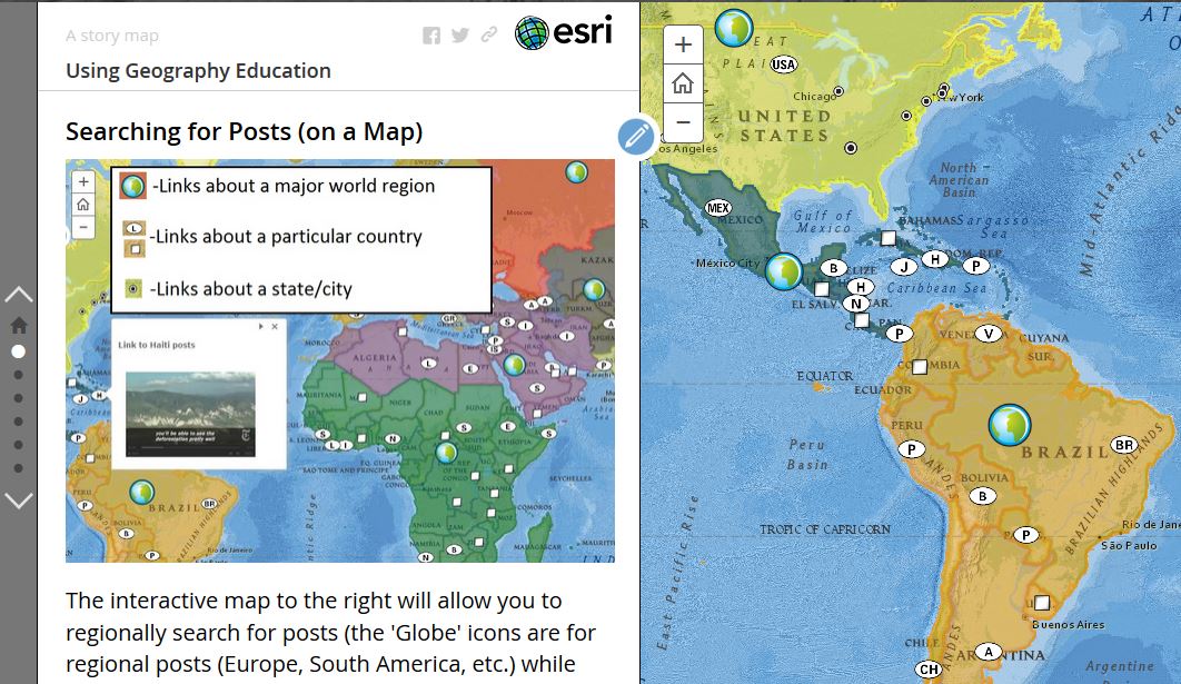
Looking for Regional Geography Readings? Simply click on the link that corresponds to your module. When you see the first 10-ish posts, if you are still looking for more options, you can click on “OLDER POSTS” to find more possible readings.
If you want thematic tags or some country-specific resources, scroll to the bottom of the site for an alphabetical list of pertinent geographic topics and countries.
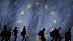
“A decade of migration through the eyes of a German city. Ten years ago Germany opened its borders to more than a million people at the height of Europe’s so-called migrant crisis. A decade later, that warm welcome has cooled as issues of culture, integration and national identity spark fierce debate across the continent. With German elections just days away, the BBC has revisited one migrant family and the city they landed in, to see how life has changed since 2015 – and what their experience says about the way Europeans now view migration. On this episode, Jonny Dymond is joined by the BBC’s Berlin correspondent Jess Parker, and Mark Lowen, the BBC’s former southern Europe correspondent who covered the refugee crisis for years.” SOURCE: BBC World Service podcast, also available on Podbay.
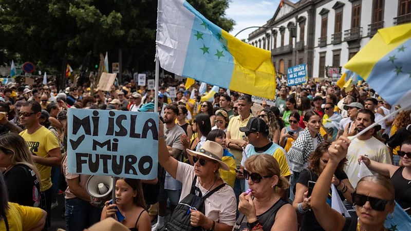
This episode of The Global Story explores the growing political tension across Europe over migration. It highlights how countries such as Germany, Italy, and Hungary experience migration differently depending on location, border access, economic strength, and political climate. Southern European states serve as frontline entry points for migrants crossing the Mediterranean from North Africa and the Middle East, while northern and western countries often become destination regions due to stronger economies and labor markets. This creates uneven social and political pressures within the European Union. The topic connects directly to regional geography themes such as spatial distribution, core and periphery dynamics, political boundaries, demographic change, and globalization. It also links to the Americas. Migration pressures in Middle America and South America, and border debates in the United States, reflect similar geographic patterns where proximity, economic opportunity, and political policy shape flows of people. This resource fits well into our study of North, Middle, and South America and Europe because it shows how migration is shaped by location, economic disparity, and geopolitical relationships rather than occurring randomly.
Questions to Ponder:
How does Europe’s physical geography, especially coastlines and border proximity, shape migration routes?
Why do wealthier northern European countries often experience migration differently than southern entry-point states?
How do migration debates in Europe compare to border and migration issues in the Americas?
In what ways do political borders both restrict and encourage the movement of people?
In this TED talk, global strategist, Parag Khanna explains how urbanization is reshaping economic and social geography, particularly in major regions like North America, South America, and Europe. Geography plays a key role in where megacities develop, often forming along coastlines, rivers, and transportation corridors that allow trade and movement of people. For example, cities like New York, São Paulo, and London grew because of their strategic access to waterways and global trade routes, which made them economic hubs. This connects directly to our textbook discussions of how physical geography influences settlement patterns, economic development, and cultural interaction. Additionally, Europe’s dense network of cities reflects its long history of trade and political fragmentation, while the Americas show patterns shaped by colonization, migration, and resource distribution. This TED Talk helps visualize how geographic location, transportation, and economic opportunity continue to shape regional development and globalization today, reinforcing the importance of spatial relationships in understanding regional geography.
Questions to Ponder:
Why do many of the largest cities develop near coastlines or rivers?
How does urbanization affect economic inequality between regions within the same country?
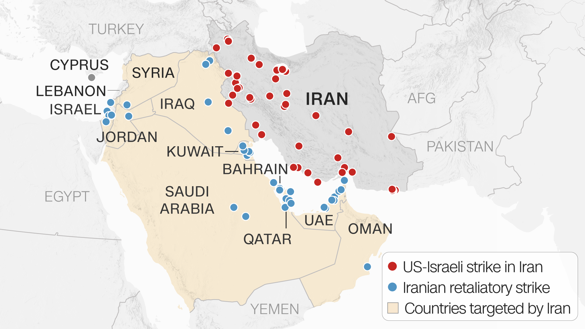
Map showing the countries bombed by Iran in the days after the death of Khamenei. SOURCE: CNN
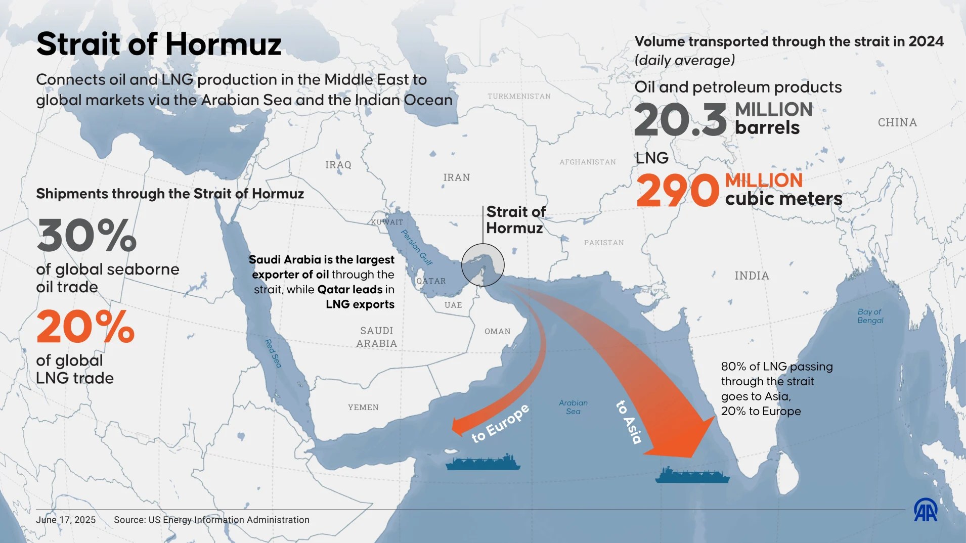
In writing this with the assumption that you’ve all seen the headlines about the US/Israeli strikes on Iran that led to the death of Iran’s Supreme Leader, Ayatollah Khamenei. Post of my students are currently asking “now what?” Things are still murky as I’m writing this, but the news often will make no sense without the regional geographic context. Understanding the Sunni/Shia divide is vital to understanding why Iran, after being attacked, bombed at least a dozen countries including many other Muslim countries. They are expending their weapons without an ability to replenish their supplies and facing. They’ve threatened to attack any ship going through the Straits of Hormuz, and which doesn’t mean much if we don’t understand what a choke point is, and why their are economic vital, and geopolitically strategic. Fellow Gulf countries like Kuwait, Bahrain, Qatar, and Saudi Arabia are seeing this as a closure as a maritime crisis that will profoundly economically damage them.
The economic and political importance of a choke point is highlighted in a crisis that closes it. SOURCE: CNBC
Nine U.S. bases in the Middle East have been bombed in drone attacks and while it is hard to assess in “the fog of war,” satellite imagery shows us the extent of the damage. Of course this has many domestic ramifications in the United States that are significant, but as a geographic analysis of this situation pulls the focus more to Middle Eastern impacts, starting with the question, “who will be in charge of Iran two months from now?” There are many possibilities ranging from the mullahs staying in charge, to the son of the Shah (Rezi Pahlavi) being installed in the future. Prior to the 1979 Islamic Revolution that installed the Ruhollah Khomeini. The current regime has been the largest state sponsor of terror and has been the greatest source of regional destabilization. They’ve funded Hamas, Hezbollah, Islamic Jihad, the Houthis, and various other Shi’ite militia groups in Iraq, Syria, and elsewhere.
The ABC video here is a good “need to know” primer for March 4, 2026…but the details will fade in time.
The news of the next few month will shape the coming decades and the possibilities are still wide open. The Caspian Report has produced good geopolitical analysis over the years, so this is their latest video (below)
I love introducing Geoguessr to my students; I love the practical geographic skills that it combines in a games that can get the competitive juices flowing. It gets users to analyze the cultural and physical landscapes, relate a stimulus to other places on Earth, use maps at a variety of scales, etc. Guess Where You Are is an alternative to Geogussr without all the bells and whistles, but it also has no time restrictions w
But I’m also a history buff and I love a good twist on a geographic game. TimeGuessr and When Taken are sites that take a great spin on the classic question, where are we? These ask where are we, but also WHEN are we? Where and when has the given photo taken? I enjoy the Daily 5 pictures from TimeGuessr. Below are three pictures from the sites that I’ve enjoyed looking at the clues to analyze what historical era and which geographic location best embody the all the elements of the stimulus. I don’t care so much about the right answer (that’s a lie, I love getting the right answer, but I don’t grade my students on their scores), I care about student’s thought process and using some geographic and historical skills as they go.
I’m very excited to be presenting in Las Vegas for the AP Annual Conference. My presentation on spatial relationships in AP Human Geography is archived here with the slides available here on Google Drive or the PDF below.
I never thought that I would be so emotionally invested in people dancing to Germans rapping tongue-twisters, but that is the modern era of cultural production and the amazing impacts of cultural diffusion. Barbara’s Rhubarb Bar–it sounds silly, and it is, but that doesn’t mean it’s simple. In fact, the deeper you go, the more delightfully complex this cultural phenomenon becomes.
This particular online story of why the dance became a viral sensation in 2024 isn’t Earth-changing, but it so perfectly shows the cultural patterns and processes in the modern online ecosystem. I was in the midst of compiling videos to help explain this when my favorite German Youtuber living in the U.S. who explains Germany for Americas (very niche, I know, but that’s want makes the internet fun) explained it far more comprehensively than I ever could because I don’t get all the references, play on words, and allusions to other styles—or in other words—the cultural context. Culture matters, even when we aren’t fully getting it.
This explains probably more context than you ever wanted…and I love it.
QUESTIONS TO PONDER:
What made this funny/fun for Germans? Americans?
What about the German language makes this distinct?
How did social media make this “a thing?”
How do other music, dance, or literary cultural traits play a role in this?
Tourism is a perfect geographic topic; the allure of exotic places, different cultural activities, and distinct cuisines drives the industry and the human impulse to experience the unknown. Tourists are drawn to unfamiliar biomes and dramatic landforms. Tourists go to see the world and experience things they wouldn’t in their homeland. I’m an unabashed advocate for experiencing more of the world as a way to learn, grow, and develop. That isn’t to say that tourism doesn’t have its downsides.
Tourists aren’t just learning about new places, often they are partying and letting loose in a place away from home precisely because they are out of their normal environment. People also go to the same places that are iconic, in search of the perfect Instagram shot of the most viral Tik Tok video. Some places are getting a massive seasonal influx of tourists, more than the local transportation network can handle.
The British media is especially (BBC and the Guardian) aware of this topic, publishing pieces about the adverse impacts of tourism. The negative stereotypes (loud, drunk, culturally insensitive, etc.) are more than off-putting to the local residences in party destinations like Ibiza. People flock to some party destinations, and the picturesque rural community can be confronted with needing a stronger nighttime police force to deal with public drunkenness and more serious criminal activities.
QUESTIONS TO PONDER: What are the responsibilities of tourists? Can a region both foster a tourist-based economy AND keep the place untouched by the industry?
“GeoInquiries™ are short, standards-based inquiry activities for teaching map-based content found in commonly used textbooks. Each activity is designed using a common inquiry model and can be presented quickly from a single computer and projector or modified for students’ hands-on engagement. Collections of 15–20 activities per topic enhance your curriculum throughout the year.” SOURCE: ESRI
ESRI has produced GeoInquires for many diverse subjects, from American Literature to World History. Not surprisingly, I’m especially interested in the AP Human Geography collection with 15 mapping activities that align with content and skills of the course. You don’t need mapping expertise to use these lessons–check them out!
“The news that the world has America, not Italy, to thank for the tomato base on pizza has gone down about as well as putting cream in carbonara among Italian gastro-nationalists. In a new book called La Cucina Italiana Non Esiste (literally “Italian Cuisine Does Not Exist”), food historian Alberto Grandi claims, among other things, that Italians only discovered tomato sauce when they emigrated to the Americas, where tomatoes are native, in the 19th century.” SOURCE: The Independent
A food historian has kicked up controversy after claiming that there is ‘no such thing’ as Italian cuisine, sparking debate over the origins and ownership of food. But perhaps we should reconsider our ideas about so-called ‘national dishes.’
This article highlights great, everyday examples that shows how cultural patterns and processes change and why they matter. Places and cultures are proud of what they see as their accomplishments that are foundational to their heritage. Interestingly though, many communities jealously guard what they see as their contributions as dislike hearing that their other communities may have had a hand in that contribution.
In an analogous example to those given in the article, Mexicans are very proud of their cuisine, but must remember that nothing is created in cultural or geographic isolation. Street tacos made with meat cooked on a rotating spit (al pastor) came to Mexican after WWI and the collapse of the Ottoman Empire. Migrant from what are now the countries of Syria, Lebanon, Israel, and Turkey brought the Middle Eastern traditional manner of cooking meat and it became a new thing when it can to Mexico. So, is it “authentically” Mexican? Of course it’s still authentic, but there is a tendency in some circles to judge something to be less authentic when the origins are more diffused. I think we should resist the temptation though, to judge the value of a culture or a cultural trait based on it’s perceived “authenticity” or “purity.” Cultures all over the world have their own regional variants of flatbread—partly as a result of stimulus diffusion from other places and partly bringing their own local flavor and customs. Cultures are delightfully intermixed, and the diffusion of cultural practices is what leads to continual human progress that shapes our modern world.
Towards the end of the article, they say: “does it really matter who invented tomato sauce on pizza? Or where your croissant is from? To acknowledge that one country might have had an impact on the food of another isn’t to be complicit in cultural appropriation. Point to any dish on a menu and you’ll have a hard time finding one that hasn’t got war, politics, economics, emigration or poverty to thank for its place there.” In essence, geographic processes can be seen everywhere you look.